Participatory Visual Research in Digital Times
How images get created, where they circulate, and where they are displayed or glanced at or studied
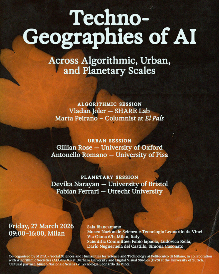
What is geographical about artificial intelligence? How can AI be understood not just as a socio-technical condition, but also as a spatial one? These questions are at the heart of Techno-Geographies of AI, an international one-day workshop that approaches AI as a geographical phenomenon across algorithmic, urban, and planetary scales. From the algorithmic operations that shape judgement and decision-making, to the automated infrastructures that organise and govern urban life, to the planetary dynamics that entangle computation and geopolitical power, the workshop opens a critical reflection on the spatial dimensions of contemporary AI systems.
Ahead of the workshop, we republish a text by cultural geographer Gillian Rose, one of the invited speakers, as part of a programme that also includes Vladan Joler and Marta Peirano, among others. Rose’s upcoming talk, Visualising Urban Life with Artificial Intelligence, reflects her long-standing interest in how images participate in the production of geographical knowledge, and in how such knowledge can also be understood as expressive of power relations in the world.
The workshop will take place on Friday, 27 March 2026, from 9.00am to 4.00pm at Sala Biancamano, Museo Nazionale Scienza e Tecnologia Leonardo da Vinci, Via Olona 6/b, Milan. It is a joint initiative of META – Social Sciences and Humanities for Science and Technology at Politecnico di Milano, Algorithmic Societies (ALGOSOC), and Digital Visual Studies (DVS), with the Museo Nazionale Scienza e Tecnologia Leonardo da Vinci as cultural partner. NERO will also take part as an exhibiting publisher.
The workshop is open to all, but registration is required as places are limited. The programme also includes an evening event at the same venue, from 6.00pm to 7.30pm, in Italian, with artist and researcher Vladan Joler in conversation with journalist Alberto Puliafito (Slow News / Internazionale).
The following essay was already published on the author’s blog Visual/Method/Culture on May 27th, 2025.
I was part of a panel event a few weeks ago discussing two long-term participatory research projects, both working with visual imagery to give voice to the inhabitants of marginalised housing estates in London and Paris. This is the text of that talk, which offers a few reflections on the implications of that kind of work when visual culture is now mostly digital. The talk was very sketchy and provisional, but the discussion was great and I’d like to thank Andrew Harris and Juliet Carpenter for their generous engagement with my sweeping over-generalisations. Here goes:
As a geographer, I’m interested in where and how images get created, where they circulate, and where they are displayed or glanced at or studied. And in recent years, I’ve got particularly interested in how digital technologies might be changing all those things—what images show, what they look like, how they’re made, how they circulate, how they get seen, what they do.
So I thought what I might bring to this discussion is a few comments on how some of those digital dynamics might play out in relation to the kinds of projects that Juliet and Andrew have discussed.
I’ll begin with a few words about the technologies that make images of cities, and the importance of technologies to what can be pictured about working-class suburbs, estates, slums, banlieus, ghettos… and I’ll do that with a scene I remember from a community video made as a participatory project, sort of, in the east end of London in the 1970s called Fly a Flag for Poplar (you can watch it here). Poplar then was a working-class area dominated by poorly paid factory work and dock labour, and Fly a Flag for Poplar recorded—and facilitated—a campaign for a local community centre. It celebrated the area’s history of community solidarity and radical working-class politics, and it also showed the making and screening of the film. And in those scenes you could see the filmmakers carrying huge battery packs and massive video cameras.
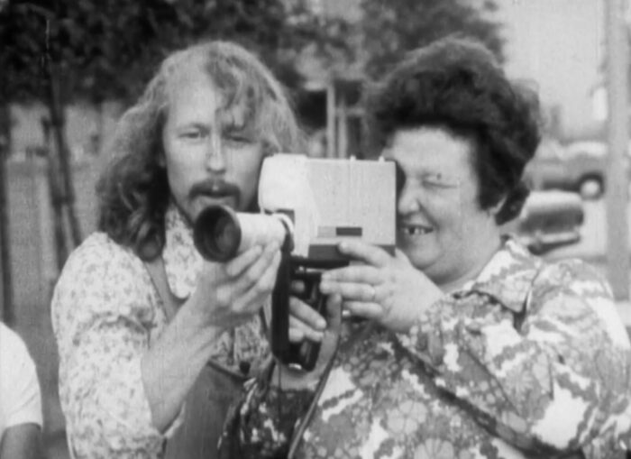
So the community arts movement, as it was called then, was enabled by certain kinds of technologies, including portable video cameras. Technologies matter to the kinds of knowledges that get made about places. But the community arts movement was also propelled by a discourse about class politics, feminist politics, about solidarity and participation, about the ideological nature of mainstream mass media, and about letting unheard voices speak in order to enable progressive social change and transformation, and that framed how those cameras were used.
Technologies and discourses have shifted since then, of course, although there’s a lot that still resonates from that early participatory work. One example is Juliet’s elaboration, with Christina Horvath and others, of co-creation as a particular form of participatory practice which engages agonistically with multiplicity and difference, living with the difference rather than trying to resolve it in the name of “community,” for example. There’s also some thinking with postcoloniality, and about the relations between colonies and urban estates in the colonial metropole. And there are still very many ‘local’ projects getting on with the work of facilitating marginalised voices and visions in these and other ways.
So how might “the digital” relate to that significant, diverse body of practice that’s emerged over the past fifty years of cultural activism? How might digital forms of image production, circulation and reception engage with that work, be part of it, emerge from it?
To offer a few very provisional and preliminary responses to that question, it’s necessary to think about both technology and discourse and their relations, again.
As the internet emerged along with personal computers in the 1970s and 1980s, it was accompanied by a rhetoric of freedom—the internet was going to be a space in which all voices could indeed be heard. It was a network for distributing information which was not controlled by traditional media corporations, and its listservs and websites would enable diverse voices to flourish. And as the web got established, and blogging platforms and social media platforms emerged, and phones with cameras connected to the internet became common, some of the commitments and practices of resistance to dominant narratives found their way online. Blogs provided alternative sources of news, and there was a lot of excitement about citizen journalism in the noughties, I recall. Initially, then, digital communication technologies were seen as a potential tool to amplify marginalised voices—and indeed, to an extent, they still are, and rightly so.
However, things are changing, clearly. With the rise of massive tech corporations and a tech entrepreneurial startup culture, what’s becoming more visible is what Orit Halpern and Robert Mitchell have called “the smartness mandate.”
The smartness mandate assumes that the world can and should be converted into data, into things that software can process, compute. There are a number of claims here. One is that the world—cities—are in crisis and that one way to be resilient in crisis is to gather data, model scenarios, and manage infrastructure efficiently. So we get the cyber city, intelligent city, the smart city, the “city brain,” which are all various versions of sensors gathering data automatically, from the urban environment, from air quality to traffic to phone location, integrating it and analysing it “in real time.” Another imperative—which Halpern and Mitchell say less about—is surveillance and security, which I’ll come back to. And another is profit—if data is necessary, those corporations that can gather and process data most “effectively” can also generate profits.
So in very general terms, in all sorts of complex ways, we might reflect on the consequences of “the city” becoming a database. Or at least, of urban life being understood—in some dominant narratives—as a database, or multiple databases, for different purposes, owned by different kinds of organisations. In which urban inhabitants participate with or without consent.
Visualisation matters to this datafication of urban life in two ways.
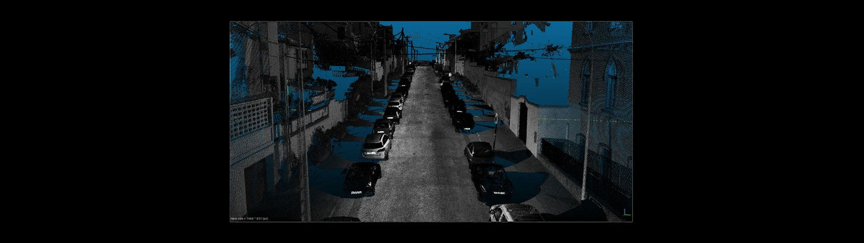
First, data itself must be visualised. There’s the importance of more conventional data visualisations like graphs, or maps, key performance indicator dashboards, or the “visual journalism” in the online versions of The Guardian or Financial Times newspapers. But all digital images are composed of data. So as well as lidar scans and drone footage that often look quite strikingly new, digital images that draw on pre-digital conventions—maps, photographs, animations and so on—might also be described as data visualisations. In all these formats, the data on which the smartness mandate depends has to be visualised and seen.
But secondly, those techniques of visualisation—especially newer ones, like digital twins or Lidar—are themselves visualised in various kinds of adverts and promotional materials, to persuade us that urban life should be lived digitally, with our phones, alongside other sensors, looked over by surveillance cameras and control centres. There’s lots of hype in this kind of imagery. But it’s possible to see similar assumptions in much of more everyday digital visual culture, in games and films and social media. There’s a constant presentation of life, and urban life especially, as if it is, and should be, lived through digital devices.
And in many cities, everyday life is indeed lived more and more with and through screens. Not entirely of course, but their presence and integration into the everyday is reconfiguring urban textures. We see imagery on phone screens of course but we also see it on all sorts of other screens. There’s the constant animation of screens, as moving images stream across them, showing us everything from films to news headlines to café menus to tiktoks. And we glance and share and comment and stare and like and upload. With that engagement and distribution there’s a kind of convergence between all of that onscreen content, as we move through streets and stations and shops and malls, glancing at screens in our hands or on walls or in the hands of others.
This means, I think, that it’s increasingly difficult to make a separation between mainstream media and its challengers—whether visually, or in terms of data production, or in terms of style, or circulation—they all stream across the same screens…
And that complicates the task of challenging dominant urban narratives. Clearly, mainstream news reporting, photojournalism and documentary photography projects continue to draw on existing tropes of urban decay and desperation, as do a lot of computer games and tv shows and films and adverts. But there’s so much more than just “the mainstream” (what even is that any more?), and it’s messy and distributed and hybrid and multiple and awful and playful. An effective challenge has to match the specific problem, right. And if the form of dominant narratives are changing in this way, then the tactics of resistance may also need to shift.
One consideration is that comparing that dominant digital imagery to other, apparently more “accurate” images might encounter the problem that many of the urban digital technologies deployed as part of the smartness mandate also play on the assumption that they can see cities super-accurately—as data. A prime example is lidar and its use in driverless cars to accurately identify pedestrians—soon to be joined by other robots in urban streets using lidar to navigate. There’s also facial recognition technology, which claims to be able to automatically and accurately identify individuals from surveillance camera footage using machine vision. City digital twins are also advocated for their apparent objective accuracy in representing urban environments.
For all the claims to accuracy, though, there’s clearly a limit to how the smartness mandate visualises cities. In looking at adverts for city digital twins, or at discussions of other more technical devices for urban management like agent-based simulation models—which are used to model pedestrian flow, floods and so on—certain kinds of urban forms are missing, for example. There are no suburbs, or informal settlements, or medieval street layouts. What is shown most often are city centres, with grid plan streets, almost always with tower blocks, but it’s assumed that they are offices, not homes. There’s a sense then that domestic life doesn’t really matter to the city, or perhaps better, The City as corporation.
These technologies speak to an assumption that is made uniformly across the smartness mandate, I would say, which is that data might be partial or need cleaning but that once those technical challenges are achieved, data is not contestable. In all the reading I’ve done around city digital twins, for example, I’ve never seen discussions of data justice, or of data feminism—which insist that all data is produced in and for social power relations, and should therefore be understood—and literally seen as—as in some way provisional, situated.
There’s also no acknowledgement of multiplicity, of different views, of different ways of seeing the city. There’s no agonistic way of seeing, but rather as an assumption that the city is a singular thing. I’ve also been struck by the persistent use of the aerial view in much of this urban imagery—from a drone or just flying untethered—this is literally the god trick of flying over the city, from nowhere, claiming to see everywhere.
Indeed, I think the central problem with the visual articulation of the smartness mandate is its assumption that there is just one city, literally visible from one viewpoint, and it is available to be managed (even if the most effective forms of management may need repeated modelling, simulation and experimentation). So maybe the critical focus needs to be on multiplicity, on seeing digital multiplicity using multiple digital and non-digital tactics, multiplying ways of seeing. Sometimes accuracy really matters. At other times, something more playful may land better. And established approaches may remain robust.
Along those lines, here are a few concluding suggestions, less for a counter-visuality in the sense of an alternative vision of the urban, and more about using digital potentials to reconfigure the field of urban visuality itself into multiple urban visions. All come from my conviction that conceding “the digital” to the corporations seems, at this point, both pointless (that horse has long since bolted), but also giving away some potential tools that might contribute to dismantling the master’s house. Here goes:
- engage with big, real-time data but think about how to visualise it differently—as dirty, messy, inaccurate, provisional, contradictory.
- move away from the paradigm of the insightful documentary image—think how the visual abstraction of data visualisations, or of agent-based models for example, might offer opportunities to resist photorealistic tropes of difference and desperation.
- again, move away from the paradigm of the insightful documentary image and think about the potentially disruptive seriality and temporality of online scrolling through tiktok and instagram.
- or, stay offline, away from training sets used by Artificial Intelligence to generate its cliche-ed slop…
- … but also maybe play with AI, to imagine new urban worlds, to generate different visual languages.
- and in a world in which AI is going to be increasingly important, stay with the creativity and randomness and ambiguity and calculations and whatever seems unArtificial.
The latter point is a clumsy way to avoid lapsing into a romantic celebration of “human” creativity as the Other of AI—but that’s probably a topic for another blog post.